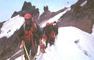
THE TOROS (TAURUS) MOUNTAINS (3756 m.)
The Toros (Taurus) Mountains are the western - most branch of the great mountain chain that stretches across of Asia - the Himalayan mountain belt. The Turkish section of this massive mountain range follows the southern border of Anatolia and is itself made up of four major sections, the Western, Central, Southern and Southeastern Toros (Taurus) ranges. The highest peaks rise out of the Central and Southeastern branches, a stretch of mountains which are rugged, magnificent and arduous to climb.

Ala Mountains Cappadocia
THE TOROS ALA MOUNTAINS
Forming part of the Central Toros (Taurus) range, the Aladaglar range runs from the southwest to the northeast for approximately 50 kilometers and boasts the region's highest peak, Demirkazik which stretches to 3756 meters. Other high summits include Kizilkaya in the center (3725 m.) , a peak that reaches 3688 meters in the south, and Mount Vayvay in the east (3565 m.). This long range, situaded in the provinces of Nigde, Kayseri and Adana, rises between Lake Ecemis and Zamanti River.
The geology of the area is responsible for the interesting rock formations and waterfalls. The erosion of limestone has created a fascinating karstic topography and hydrography, especially in the Yedigöller valley, where karstic underground river and caverns collect the surface water. Both the Mediterranean and Anatolian weather systems influance the climate of the Aladaglar bringing warm summers and cool winters to the mountains.
Trips and Climbs The best season to climb the mountains is during May, June, July and August when the alpine meadows of the higher elevations are rich in vegetation.
Researces and mountaineers ascending the Aladaglar usually begin their climb from either Camardi or Cukurbag villages. Those attempting to climb the demirkazik summit depart from Demirkazik village. Both of these villages lie 65 km from Nigde and can be reached by asphalt road.
Regional Attractions The yaylas of the Toros (Taurus) Aladag are the summer homes of entire villages and the summer grazing of herds of animals. Be sure to see the rounding up of all the animals for milking. Traditionally women of these encampments have produced some of Turkey's most beautiful carpets and kilims, and it is often possible to see a carpet still in progresis.
MOUNT ERCIYES
One of the Turkey's most important mounteering and winter sports centers. Mount Erciyes rises from the south of the Kayseri valley. The Sultan Marses lie to its west and to the south falls the Develi valley. Its summit always covered in snow and ice. Mount Erciyes ranks as Central Anatolia's tallest volcano.

Mountaineers on the Cappadocia
Trips and Climbs Mountaineers attempt Mount Erciyes either on the northwestern flank or from the south and find the best climbing in June, July, August and September.
Regional Attractions Tourists visitng the area should also see the fantastic rock formations, underground cities and fabulous frescoes in rock carved churces in neighboring Cappadocia. The Sultan Marses, a habitat for many different species of birds, has fortunately been designated a National Park and wildlife preserve.


